


Aumont Aubrac - les Quatre Chemins

VANDERPUTTENMi
User GUIDE
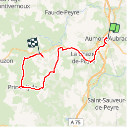

Length
25 km

Max alt
1245 m

Uphill gradient
475 m
Km-Effort
31 km

Min alt
1015 m

Downhill gradient
358 m
Boucle
No
Creation date :
2019-06-22 06:52:34.983
Updated on :
2019-06-23 06:37:27.049
7h18
Difficulty : Very easy

FREE GPS app for hiking
 SityTrail
IGN / Geographical institutes
SityTrail Plus
The world is yours!
About
Trail Walking of 25 km to be discovered at Occitania, Lozère, Peyre en Aubrac. This trail is proposed by VANDERPUTTENMi.
Positioning
Country:
France
Region :
Occitania
Department/Province :
Lozère
Municipality :
Peyre en Aubrac
Location:
Aumont-Aubrac
Start:(Dec)
Start:(UTM)
522658 ; 4952091 (31T) N.
Comments